 ViewRanger
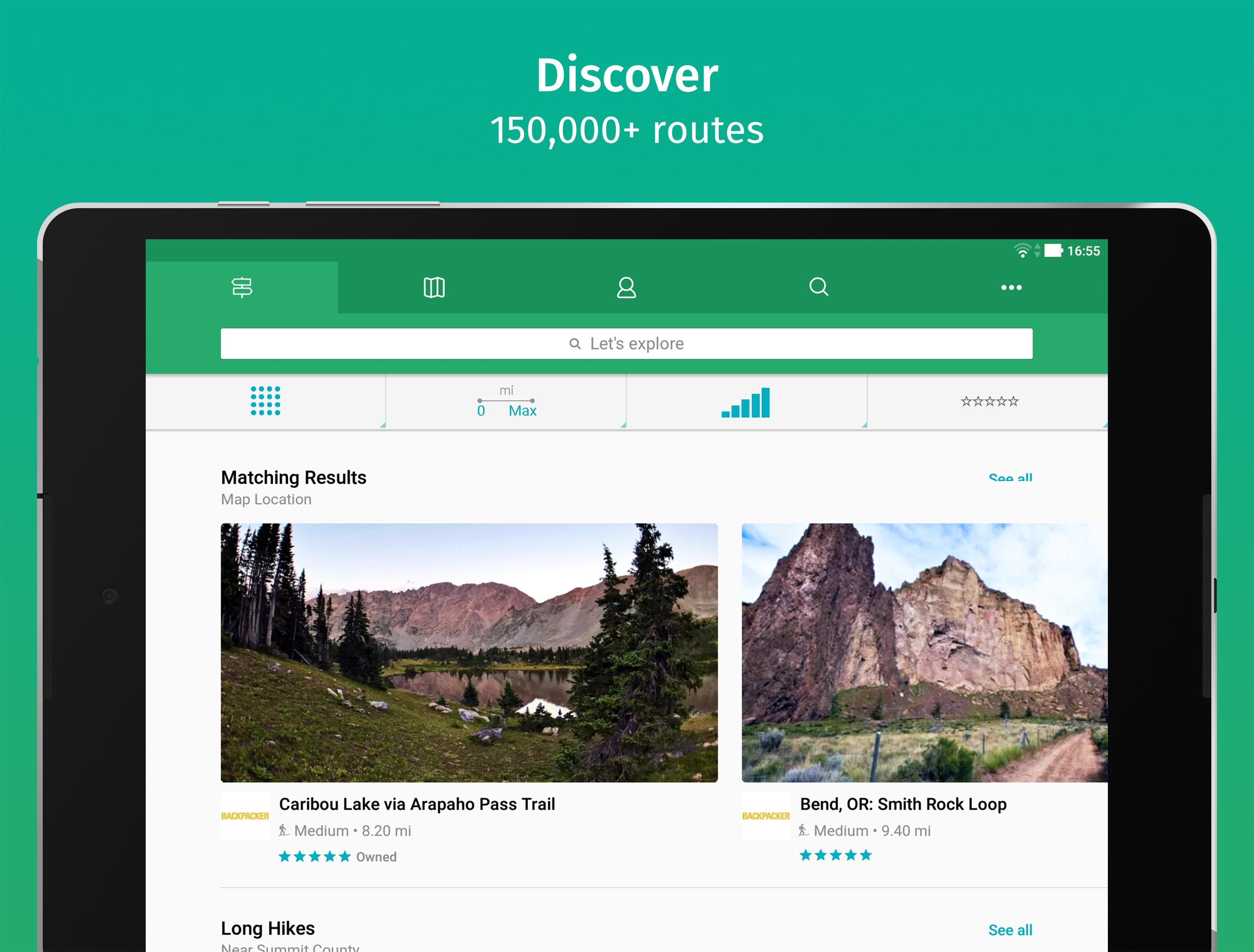

Find hiking trails and bike rides, navigate with GPS, and save offline topo maps
ViewRanger is now Outdooractive.Goodbye from us. We have now switched off access to the ViewRanger app. Thank you to the global community of ViewRanger users who helped make our adventures so much fun.We recommend you download and use the Outdooractive app instead of ViewRanger. We offer you an easy way to move to the Outdooractive app - where you can continue to access your maps, tracks, routes, POIs, and other ViewRanger app data.Search for "Outdooractive" and download the app for free. Well see you in the Outdooractive communityYour MapsIf you made one-off payments to access maps within ViewRanger, then we are offering free access to a set of maps via the Outdooractive app instead. The maps we are offering depend on the region of the maps you made one-off payments for in ViewRanger. The maps will be from the same map data provider or, where necessary, from an alternative map data provider depending on the map region.If you have a current ViewRanger subscription, then you have an Outdooractive Pro subscription that will expire at the same time as your ViewRanger subscription. You will then need to renew your subscription via the Outdooractive app. It is no longer possible to purchase or renew a ViewRanger subscription.Other DataBy connecting your ViewRanger account to Outdooractive, routes you have plotted, routes you have downloaded, activity tracks you have recorded, a record of the challenges you participated in, and points-of-interest you have marked, will continue to be available within your Outdooractive account.>> OS WEAR by Google• Navigate trails and view track stats on your wrist with OS Wear enabled smartwatches.• Record a new track and pause or stop an existing track recording.• View heading, bearing, lat/long and altitude data.OTHERFree Global maps © OpenStreetMap contributors.Some features, such as viewing online maps, browsing routes, downloading maps and routes and sharing your location using BuddyBeacon require an internet connection.Goodbye from us. We have now switched off access to the ViewRanger app. Thank you to the global community of ViewRanger users who helped make our adventures so much fun.We offer you an easy way to move to the Outdooractive app - where you can continue to access your maps, tracks, routes, POIs, and other ViewRanger app data.Search for "Outdooractive" and download the app for free. Well see you in the Outdooractive community
ViewRanger is now Outdooractive.Goodbye from us. We have now switched off access to the ViewRanger app. Thank you to the global community of ViewRanger users who helped make our adventures so much fun.We recommend you download and use the Outdooractive app instead of ViewRanger. We offer you an easy way to move to the Outdooractive app - where you can continue to access your maps, tracks, routes, POIs, and other ViewRanger app data.Search for "Outdooractive" and download the app for free. Well see you in the Outdooractive communityYour MapsIf you made one-off payments to access maps within ViewRanger, then we are offering free access to a set of maps via the Outdooractive app instead. The maps we are offering depend on the region of the maps you made one-off payments for in ViewRanger. The maps will be from the same map data provider or, where necessary, from an alternative map data provider depending on the map region.If you have a current ViewRanger subscription, then you have an Outdooractive Pro subscription that will expire at the same time as your ViewRanger subscription. You will then need to renew your subscription via the Outdooractive app. It is no longer possible to purchase or renew a ViewRanger subscription.Other DataBy connecting your ViewRanger account to Outdooractive, routes you have plotted, routes you have downloaded, activity tracks you have recorded, a record of the challenges you participated in, and points-of-interest you have marked, will continue to be available within your Outdooractive account.>> OS WEAR by Google• Navigate trails and view track stats on your wrist with OS Wear enabled smartwatches.• Record a new track and pause or stop an existing track recording.• View heading, bearing, lat/long and altitude data.OTHERFree Global maps © OpenStreetMap contributors.Some features, such as viewing online maps, browsing routes, downloading maps and routes and sharing your location using BuddyBeacon require an internet connection.Goodbye from us. We have now switched off access to the ViewRanger app. Thank you to the global community of ViewRanger users who helped make our adventures so much fun.We offer you an easy way to move to the Outdooractive app - where you can continue to access your maps, tracks, routes, POIs, and other ViewRanger app data.Search for "Outdooractive" and download the app for free. Well see you in the Outdooractive community
Read trusted reviews from application customers
Best App Ever!!! And Still working at present....(Just use apk version 10.11.56 & use your purchased map tiles..) I would give it a thousand more stars rather than use outdooractive.....
It works unlike outdoor active
Quelques erreurs de manipulation au début, mais tout est là et fonctionne bien. Sauf l'élévation cumulée qui est largement surevaluée. Continuez! I revise my initial review. VR was showing the distance to the goal, the elevation difference; I do not find them again. In addition, VR was working fine with few ressources (3G of RAM, small processor) whereas OA is just not usable and crash on the same device. The filters are filtering their ways, the stats like distances and elevation show contradicting totals. Where I was confident with VR, I get suspicious with OA. Advertizing occupies too much space in the free OA, and confidence is to low to invest in it.
Bad facilities after merging
Looks really nice. Thought it would be what I need but it sent me to a different app.. outdoor map that is out dated.
VR was the best, I thought. But that's only because I didn't know about AlpineQuest. That's the replacement I've settled on now that VR users have been sold out, and it turns out to be vastly superior in every way. AlpineQuest customer support is fantastic too. All POIs, tracks and routes imported no problem. DO NOT MOVE TO OUTDOORACTIVE THINKING THAT IT IS AN UPGRADE OR "THE NEW VIEWRANGER". It is not. It is terrible. They were only interested in buying users and trying to force them to switch.
19-4-2022 To people looking for an alternative like myself: for the moment I recommend LOCUS. It does pretty much the same thing as ViewRanger. But the attractive thing is one can SIDELOAD OpenStreetmap from Mapsforge sources, possibly with separate styles. 20-3-2022 Oh, as a farewell present: UNINSTALLING ViewRanger failed miserably. I only got rid of it by manually deleting the cache, step by step. 5-3-2022 So Outdooractive has even SABOTAGED Viewranger. I expected them to pull the plug on downloading new maps through the application. But then I would just continue to use the application as is. As long as I had appropriate maps in it, which in fact I downloaded previously for some expected areas. No-no, they put a time bomb in it. So stupid! Outdooractive probably bought Viewranger just for the user base. But that is not going to fall for it, as the reviews are BAD, and I don't think they allow the use of Open Streetmaps. So they just just DESTROYED an application I was happy to use. And by the way, I am contributing to Open Streetmaps myself.
Discontinued
As others, the buyout by OA and killling of VR is horrendous. OA can kiss it, there are far better alternatives than their shonky app. VR was indispensible and the team should be lauded for bringing it to us - but Mammon strikes again.
Loved this app and extremely sad that it has been shut down. It was the best tracking app I have used. The new app is not nearly as user friendly or easily customizable. Wish they would bring it back.